10:15 AM | **Heavy rain event for the Mid-Atlantic with 2+ inches on the table…very unstable on Friday with wind gusts to 40 mph and numerous snow and/or rain showers**
Paul Dorian

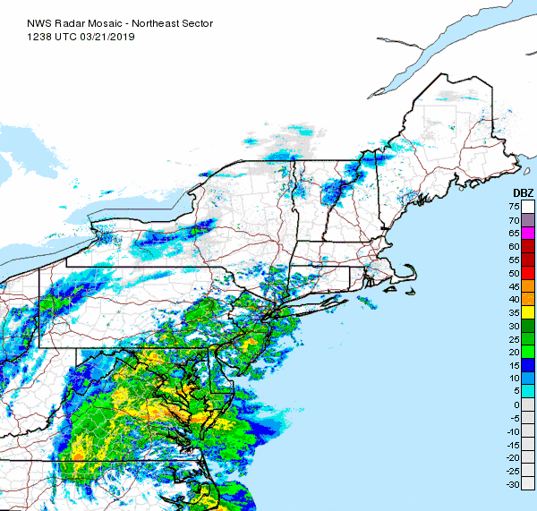
Heavy rain bands are rotating around intensifying low pressure near the Mid-Atlantic coastline; courtesy NOAA
Overview
Low pressure will intensify rapidly along the eastern seaboard over the next 24-36 hours resulting in a heavy rain event from today into early Friday in the Mid-Atlantic region. Rainfall amounts of more than two inches are possible by late tonight and flash flood watches have been posted in a large area given the saturated grounds. In the higher elevation interior sections from western Virginia/West Virginia/southwestern Pennsylvania to northern New England significant snow is likely to occur during this event as colder air will wrap into the system later today and tonight.
By later tomorrow, the strong low pressure system will be near the southern part of Maine, but that won’t be the end of the story for the Mid-Atlantic region in terms of inclement weather. An Arctic cold blast supported by a strong wave of energy in the upper atmosphere will slam into the Mid-Atlantic/Northeast US later tomorrow and this will result in wind gusts of 40 mph or so and numerous snow and/or rain showers. The wind and cold will stick around during the first part of the weekend in the DC-to-Philly-to-NYC corridor, but it’ll turn noticeably milder and calmer on Sunday with 60 degrees possible in DC and upper 50’s in Philly and NYC.

Total rainfall amounts may exceed two inches in parts of the Mid-Atlantic region by later tonight and this can result in localized flash flooding given the already well-saturated grounds; map courtesy NOAA
Heavy rain event today/tonight in the Mid-Atlantic
Low pressure is currently situated over North Carolina and it will undergo significant intensification over the next 36 hours. The current central pressure of the low pressure system is around 1010 millibars (29.83 inches) and it could very well bottom out near 983 millibars (29.03 inches) by early tomorrow night over Maine. Latest radar shows multiple bands of rain rotating around the developing low pressure system and some of these bands will feature torrential downpours. The rain will continue at varying rates of intensity through the day and evening hours and then diminish to a showery-type of pattern late tonight in the I-95 corridor. Flash flood watches have been posted for much of the Mid-Atlantic region given the well-saturated grounds and the chance for 2+ inches of rain in many spots. Another concern during this heavy rain event is the good chance for coastal flooding at times of high tide from the Delmarva Peninsula coastline to Long Island. The combination of onshore flow, heavy rainfall and the nearly coincident full moon raises the chances for coastal flooding issues at times of high tide; especially, later this evening. In addition to the rainfall, this storm system is likely to generate significant snowfall across interior higher elevation locations from western Virginia/West Virginia/southwestern Pennsylvania all the way to northern New England.
An unstable Friday
On Friday, a second strong wave of energy in the upper atmosphere will drop into the Mid-Atlantic/Northeast US and accompany an Arctic frontal boundary zone. The result of this will be quite an unstable atmosphere with windy and cold conditions and there are likely to be numerous snow and/or rain showers along with wind gusts of 40 mph or so. A very tight pressure gradient later tomorrow between the powerful storm system over Maine and strong high pressure over the western Great Lakes will help to generate these strong wind gusts. The best chance for the snow and/or rain showers will likely be in the PM hours as the atmosphere will become most unstable tomorrow afternoon and evening. The wind and cold will stick around in the Northeast US and Mid-Atlantic region on Saturday, but noticeably milder and calmer conditions are coming for Sunday.
Meteorologist Paul Dorian
Perspecta, Inc.
perspectaweather.com
Video discussion: