
11:15 AM | **Snow showers possible later today in the I-95 corridor…snow threat continues for Friday**
Paul Dorian

2-meter temperature for early this afternoon show just how widespread this cold air outbreak is with below-normal conditions extending virtually from coast-to-coast; courtesy NOAA/EMC, tropicaltidbits.com
Overview
A widespread outbreak of Arctic air continues to grip the nation and today may feel the worst in the Mid-Atlantic region as strong winds will produce wind chill values in the single digits at times. In addition to the unusual cold and wind, instability in the upper atmosphere is already generating snow shower activity in upstate Pennsylvania and New York and some of these can make it into the DC-to-Philly-to-NYC corridor later today with an isolated snow squall even possible. The next low pressure system to monitor will trek across the nation over the next 48 hours and reach the Mid-Atlantic region on Friday. Snow may break out in the I-95 corridor during the mid-day or afternoon hours on Friday and there can be some small accumulations from this system. Another system will bring mainly rain to the Mid-Atlantic region on Sunday, but it may be cold enough at the onset for sleet and/or freezing rain in some interior higher elevation locations.

Radar echoes during the late morning hours reflect the development of snow showers in upstate PA and some of these can make their way into the immediate I-95 corridor later today; courtesy NOAA
Windy, very cold today with the threat of snow showers
Temperatures are way below-normal for this time of year in the Mid-Atlantic region and indeed across much of the nation. Record or near record low temperatures were reached in many parts of the nation earlier today and many spots have had their lowest March temperatures ever during the past few days (see list below).
Monday, March 04
* -25 deg in North Platte, Neb, coldest ever in March
* -34 deg in Lewiston, Mont, coldest ever in March
* -46 deg in Elk Park, Mont, coldest ever in March
Tuesday, March 05
* -33 deg in Bozeman, MT, coldest ever in March
* 0 deg in Pasco, WA, coldest ever in March
* +8 deg in The Dalles, OR, coldest ever in March
* +21 deg in Kelso-Longview, WA, coldest ever in March
* +21 deg in Portland, OR, coldest ever in March
* +19 deg in Shelton, WA, coldest ever in March
* +1 deg in Pendelton, OR, coldest ever in March
* +7 deg in La Grande, OR, coldest ever in March
Wednesday, March 06
* -15 deg in Menominee, WI, coldest ever in March
Instability in the upper part of the atmosphere is not only resulting in strong NW winds today in the Mid-Atlantic region, but snow showers have formed over the mountains of central PA and in upstate NY and some of those can make it into the I-95 corridor later today and isolated snow squalls are even possible; especially, north of the PA/MD border. The winds will continue to rip in the Mid-Atlantic region tonight and tomorrow and more upper-level energy can again generate snow showers; primarily, to the north of the PA/MD border.

Low pressure in the Mid-Atlantic region will be aided by a wave of energy in the upper atmosphere (circled region); map courtesy NOAA/EMC, tropicaltidbits.com
Snow threat for Friday
Surface low pressure supported by west-to-east moving upper-level energy will trek across the nation over the next 48 hours and its precipitation field should reach the Mid-Atlantic region early Friday. Snow is likely to break out in the DC-to-Philly-to-NYC corridor during the mid-day or afternoon hours and small accumulations on the order of a coating to a couple of inches are possible from this system which will slide off the North Carolina/Virginia coastline on Friday night. Some rain can mix in on Friday in areas to the south and east of DC, but for the most part, this looks like a snow event to me in areas to the north of the PA/MD border and also from the District to its north and west. Precipitation winds down late Friday or Friday night and Saturday promises to be moderately cold and dry with some sunshine.
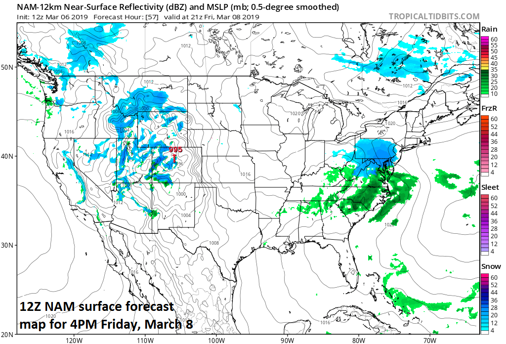
Low pressure will produce snow in the Mid-Atlantic region on Friday and small accumulations are possible; map courtesy NOAA/EMC, tropicaltidbits.com
Weekend system
A more important system in terms of total available moisture will head towards the Great Lakes region on Saturday generating significant snow for the Northern Plains where Arctic cold is firmly entrenched (north and west) and rain/thunderstorms in the storm’s warm sector (south and east). Indeed the clash of air masses this weekend between the Arctic cold to the north and west and warm, more humid air to the south and east is liable to result in another severe weather outbreak on Saturday centered across the Lower Mississippi Valley and this will include the threat of more tornado activity.
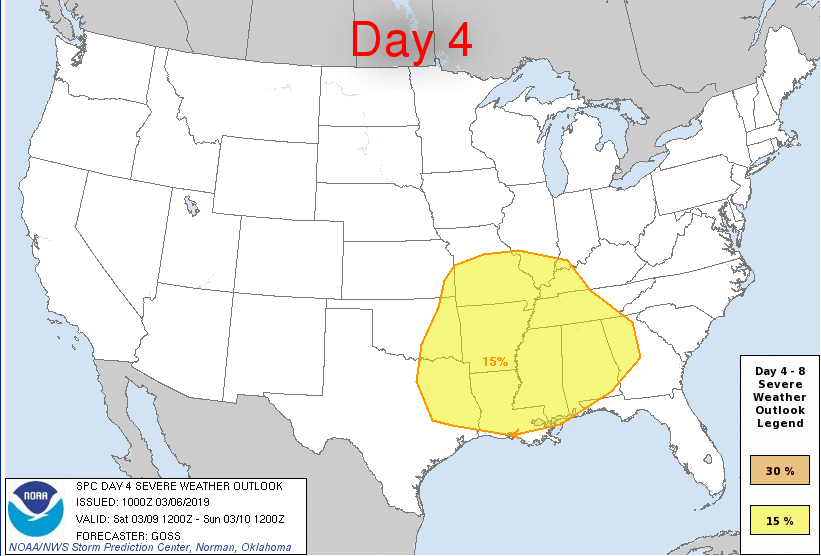
Severe weather including the threat of tornadoes is possible on Saturday in the Lower Mississippi Valley region as depicted by this forecast map by NOAA’s Storm Prediction Center (SPC).
This system will bring widespread precipitation into the eastern states by early Sunday morning and it could be cold enough at the onset for some frozen precipitation in interior higher elevation locations of the Mid-Atlantic such as NE PA, northwest NJ, and southeastern New York - perhaps even cold enough down to the suburbs of Philly. Later Sunday, rain is likely in the metro regions and temperatures can actually jump into the 50’s in the I-95 corridor ahead of the next cold frontal system which will usher in colder air for early next week.
Meteorologist Paul Dorian
Perspecta, Inc.
perspectaweather.com
Video discussion: