1:00 PM | *Atlantic Basin tropical season far from over*
Paul Dorian

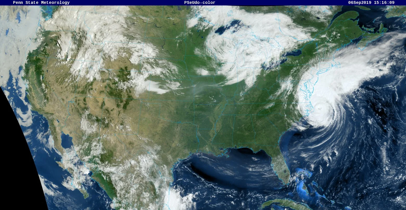
Hurricane Dorian passed over Cape Hatteras, NC this morning and is now over the western part of the Atlantic Ocean; courtesy NOAA
Overview
The eye of Hurricane Dorian passed over Cape Hatteras, North Carolina, earlier today which makes it the the first (and only) landfall by this storm on the US mainland. It made landfall on the Outer Banks as a category 1 hurricane with maximum sustained winds at 90 mph and is the first landfall by a hurricane in North Carolina since Arthur in 2014. The storm has begun an acceleration to the northeast in recent hours as it is increasingly being influenced by an approaching upper-level trough. There is still some impact being felt in coastal sections of the Mid-Atlantic and southern New England where heavy rain bands are rotating around Hurricane Dorian.

These buoy observations at Cape Hatteras, NC confirm the passage of the eye of Hurricane Dorian as winds dropped significantly and pressure dropped and rose sharply; courtesy NOAA
Discussion
The latest official measurements of Hurricane Dorian maintain its category 1 status with max sustained winds of 90 mph, but its days as a hurricane are numbered as it accelerates to the northeast and ultimately out over cooler waters of the Atlantic Ocean. This system has now been a named storm for 13 days and this is an unusually long time for storms that form in August in the Atlantic Basin.

TS Gabrielle appears to be no threat to land, but the next system in the eastern Atlantic (red path shown) may very well become an issue in a week or so in what appears to be an ongoing active tropical season; map courtesy NOAA/NHC
Heavy rain bands continue to rotate around Hurricane Dorian and impact the northeastern part of North Carolina and southeastern Virginia. In addition, bands of heavy rain are pushing northwest into the Delmarva Peninsula, New Jersey, southeastern New York and southern New England. Winds are gusting to tropical force levels at many Mid-Atlantic coastal locations with a recent report, for example, of a gust to 45 mph at Ocean City, Maryland. One final note, for the first time in 8 years ‘down east’ Maine has issued a tropical storm warning as it too will get clipped by the departing Hurricane Dorian.

A couple of weeks ago there was a widespread dry (Saharan Desert) air mass over the tropical Atlantic Ocean, but now there is little. The tropical wave in the eastern Atlantic (at right edge of circle) has an “atmospheric opening” to trek westward in coming days towards the Caribbean Sea. Courtesy NOAA, CIMSS Wisconsin
Tropical season far from over
With the imminent departure of Hurricane Dorian, it is time to look at the breeding grounds (Africa, eastern Atlantic) to see if other tropical systems are on the horizon. Indeed, there is no reason to believe that Dorian will be the last of the hurricanes in the 2019 Atlantic Basin tropical season. First of all, the typical tropical season runs from about August 15th to October 15th so we have several weeks to go on the calendar at least from a climatological point-of-view. In addition, numerous tropical waves can be seen in the latest satellite imagery over the African continent and they are all pushing to the west towards the tropical Atlantic Ocean riding along on tropical trade winds. Finally, the dry air that was a big factor in the inhibition of tropical storm formation over the tropical Atlantic during much of the month of August has dissipated quite a bit in recent days and this is a favorable sign for future activity; especially, in this the climatological peak time period for the Atlantic Basin tropical season. One tropical wave now over the eastern Atlantic may have an “atmospheric opening” to trek westward in coming days towards the Caribbean Sea without much interference.

Multiple tropical waves over the eastern Atlantic and African continent suggest the Atlantic Basin tropical season will remain active for awhile to come; courtesy NOAA, CIMSS Wisconsin