
12:20 PM (Tues) | *Low pressure to form near the east coast this weekend, but some questions remain…some of the Alaska cold tries to "break loose" in early February*
Paul Dorian
Overview
An active weather pattern will bring multiple waves of energy across Canada and the US over the next few days and a couple of these are likely to interact and generate low pressure near the Carolina coastline on Saturday. The fact that there may be multiple waves competing for energy and that these are rather fast-moving systems may inhibit the storm from intensifying rapidly until after it pushes off the east coast thereby potentially limiting its impact on the Mid-Atlantic region. Temperatures are likely to borderline on Saturday with respect to precipitation type so if precipitation does develop, there would likely be a battle zone in the I-95 corridor between rain and snow. Most of these upper-level waves of energy are still way off in the distance so details on this threat won’t be ironed out until late this week. Looking ahead to next week, there are signs that some of the cold that has been bottled up over Alaska in recent days will finally “break loose” in early-to-mid February and head towards the central and eastern US.

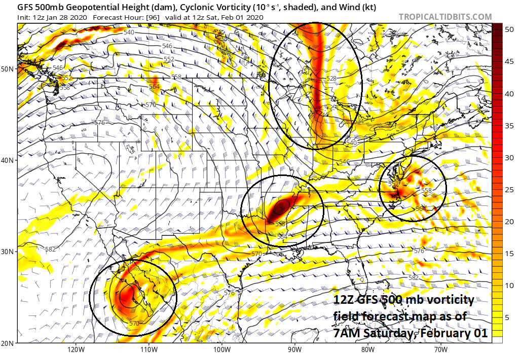
12Z GFS depicts low pressure off the Mid-Atlantic coastline on Saturday morning, but the exact placement and intensity is still to be determined as many of the important players are still far away at this point in time. Map courtesy NOAA, tropicaltidbits.com
Details
The overall weather pattern is quite active and multiple upper-level systems will move into Canada and the US from the Pacific Ocean in coming days. It appears that one northern stream system will try to interact with a southern stream system by the weekend and this could result in the formation of low pressure near the Carolina coastline by Friday night. This low is likely to then move to the northeast on Saturday and intensify, but exactly how quick and where that intensification takes place is unclear and this will determine if any significant precipitation can break out in the I-95 corridor from an offshore low. There is a chance that even if the low pressure system pushes well off the Mid-Atlantic coastline another wave of energy aloft can produce some precipitation in the Mid-Atlantic region late Saturday into Sunday. If precipitation does break out, it could in the form of rain in at least parts of the I-95 corridor as there will not be an Arctic air mass in place as we begin the weekend. This lack of Arctic doesn’t mean that snow couldn’t fall in the I-95 corridor; especially, north of the PA/MD border, but it does make it somewhat more difficult. Stay tuned, the picture on the early weekend threat may not clear up until late this week.

The current 5-day period features a continuation of unusual cold over Alaska and below-normal conditions across much of the southern and eastern US; map courtesy NOAA, tropicatidbits.com
Looking ahead, there has been abnormally cold air bottled up over Alaska in recent days (and weeks) and there are some signs that some of this will try to “break loose” in early-to-mid February and head southeastward towards the central and eastern US. A strong cold front is likely to push across the northern US early next week and it may usher in colder air around here by the middle of next week. Whether or not this shot of cold air makes it all the way into the east coast is still somewhat unclear, but, if not, another attempt of an Arctic air outbreak may take place a few days later. In addition, there will be plenty of moisture to watch across the southeastern US later next week and we’ll have to monitor it closely as it likely heads to the northeast at the same time cold air drops southeastward across the Great Lakes.

The abnormal cold that has been bottled up over Alaska in recent days tries to “break loose” in early-to-mid February; map courtesy NOAA, tropicaltidbits.com
Meteorologist Paul Dorian
Perspecta, Inc.
perspectaweather.com
Follow us on Facebook, Twitter, YouTube
Video discussion: