10:15 AM (Thurs.) | *Sahara Desert dust is pushing across the Atlantic and it should reach all the way into the southern US…an inhibiting factor for tropical activity...possible brilliant sunsets*
Paul Dorian

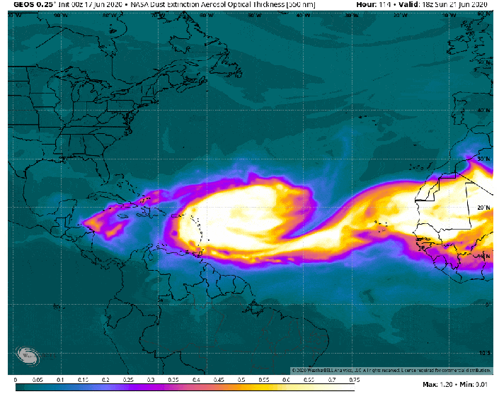
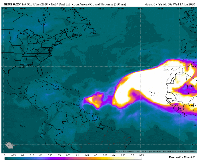
NASA GEOS-5 global atmospheric model forecast maps of dust extinction between June 17 and June 27. Maps courtesy NASA, Weather Bell Analytics
Overview
The Saharan Air Layer (SAL) is a mass of very dry, dusty air that forms over the Sahara Desert in northern Africa during the late spring, summer, and early fall and it can move westward over the tropical North Atlantic on a regular basis during the Atlantic Basin tropical season. SAL activity usually ramps up in mid-June and peaks in mid-August and sometimes the individual outbreaks can cover vast portions of the Atlantic Ocean and reach as far west as the central US and Central America. The SAL has unique properties of dry air, strong winds and warmth that can have a significant inhibiting effect on the formation and/or intensification of Atlantic Basin tropical systems - at least on a temporary basis. This outbreak of dry, dusty air is more widespread than usual and appears to have formed when strong winds from thunderstorms kicked up the dust to an altitude of about 20,000 feet in mid-June over the Sahel region of northern Africa.

The 2020 Atlantic Basin tropical season has gotten off to a quick start with three named systems already, but there is a lull in activity now likely due to inhibiting effect of dust from Africa’s Sahara Desert. Map courtesy NOAA/NHC
2020 Atlantic Basin tropical season is off to a quick start
The 2020 Atlantic Basin tropical season officially began on June 1st and it has gotten off to a rather fast start with three named systems already in the young season. Tropical Storms Arthur and Bertha formed during the month of May even before the “official” season got underway marking the sixth consecutive year with pre-season systems. In fact, this is the first time since 2012 that two or more storms formed in the month of May. In addition, Tropical Storm Cristobal became a named system on June 2nd and ultimately, it impacted the entire Mississippi Valley region from Louisiana to the Canadian border as it penetrated unusually far inland for a tropical system; especially, for the month of June. Tropical Storm Cristobal weakened and became extra-tropical by June 9th and there has been no newly named storm since that point in time. One of the reasons that the Atlantic Basin tropical season may have been temporarily halted in recent days is the fact that a Sahara Desert air mass began to push westward at mid-month over the tropical Atlantic Ocean from western Africa.

NOAA’s National Hurricane Center (NHC) based in Miami, FL is anticipating no tropical activity during the next 5 days which is likely due at least in part to the dusty, dry air mass moving westward over the Atlantic Ocean from western Africa. Map courtesy NOAA/NHC
Inhibiting effect of African dust on Atlantic Basin tropical activity
Saharan Air Layer’s dry, dusty air has about 50% less moisture than the typical tropical atmosphere according to NOAA. This layer of dust finds its origins in the Sahara Desert region of northern Africa and it typically resides between 500 and 850 millibars or 1500-5000 meters above the surface. This type of very dry (and dense) air can weaken a tropical cyclone by producing downdrafts around the storm or it can prevent one from actually forming in the first place. In addition, there are typically rather strong winds in the SAL (25-55 mph) which can substantially increase the vertical wind shear in and around the storm environment. This “mid-level jet” of enhanced winds, typically found at a height of 6,500-14,500 feet, can cause “tilting” of the tropical cyclone vortex with height which can disrupt the storm’s internal heat engine. Furthermore, the SAL’s warmth can act to stabilize the atmosphere which, in turn, can inhibit the formation of clouds over the tropical Atlantic Ocean. This stabilizing effect is produced when the Saharan Air Layer’s warm, buoyant air rides above relatively cooler and denser marine air of the Atlantic Ocean. In other words, since the SAL is warmer and drier than the surface of the Atlantic Ocean, it functions as a temperature inversion - rising temperatures with height – and this has a stabilizing effect on the atmosphere. The Saharan Air Layer’s suspended mineral dust also absorbs sunlight, which helps to maintain its warmth as it crosses the Atlantic Ocean.
High-resolution computer forecast models such as NASA’s Goddard Earth Observing System Model, Version 5 (GEOS-5) suggest that the current outbreak of Saharan Desert air can reach all the way into the southern US in coming days. A large and expansive high pressure system will build over the Central Atlantic Ocean in coming days and this will aid in the formation of an easterly jet stream in the mid-levels of the atmosphere which, in turn, will help to push the dust westward. The dust from this outbreak is likely to reach the Caribbean Sea within a few days and then the southern US by the early-to-middle part of next week. NASA’s GEOS-5 global atmospheric model is built on satellite data and it can provide up to a 10-day forecast of “aerosol optical thickness” among other things. In general, brighter colors that appear in the forecast loop represent thick aerosols while dull, darker colors are thin aerosols.

Sunsets could be quite orange or red next week across the southern US as dust from Africa arrives in the region. Image of Gulf coast beach courtesy Getty Images.
One final note, this dusty air can make the sunrise and sunsets more colorful than normal with a reddish or orange tint so be on the lookout for that; especially, across the southern US in coming days. The presence of dust in the mid and upper levels of the atmosphere creates an air mass that is rather dense and more apt to scatter red and orange light rays at sunset, leading to vivid sunsets. According to NASA, winds typically carry aloft about 800 million metric tons of desert dust from North Africa. In addition, the dust can also play an important ecological role, such as fertilizing soils in the Amazon and building beaches in the Caribbean.
Meteorologist Paul Dorian
Perspecta, Inc.
perspectaweather.com
Follow us on Facebook, Twitter, YouTube
Detailed video discussion: