
11:45 AM | **Big-time cold air outbreak sweeps across the nation next week…strong storm system to impact a large part of the country ahead of the Thanksgiving Day holiday**
Paul Dorian

A cold air mass will push from northwest-to-southeast next week and reach the eastern seaboard just in time for the Thanksgiving Day holiday. Map courtesy NOAA, tropicaltidbits.com
Overview
A widespread and impressively cold air mass will cross the nation next week and reach the eastern seaboard in time for Thanksgiving Day (Thursday). A strong storm system will develop out ahead of the incoming cold air mass and it will impact a large part of the nation with rain, snow and wind on the busy travel days of Tuesday and Wednesday.

00Z Euro forecast map of 500 mb height anomalies suggest the polar vortex will drop southward by the middle of next week to a position centered over the Great Lakes. Map courtesy ECMWF
Details
Much of the nation features above-normal temperatures today, but there will be a big-time cold air outbreak next week that will cross the nation from northwest-to-southeast. This cold air mass has been building in recent days over some deep early season snowpack across Alaska and northwest Canada and an upcoming change in the upper air pattern will allow it to drop to the south and east next week from northwestern Canada into the US. This cold air outbreak will be quite unusual for this time of year as it will likely feature temperatures as much as 20 degrees below-normal along much of its path. The cold shot reaches the east coast of the Mid-Atlantic just in time to result in quite an unusually cold Thanksgiving Day.
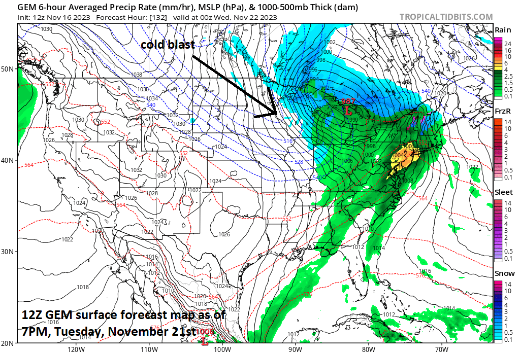
A strong storm system will push towards the eastern Great Lakes by later next Tuesday with rain, possibly heavy, in the Mid-Atlantic region. In the colder air across interior sections of the Northeast US, snow may fall for awhile and a tightening pressure gradient field will cause winds to become quite strong in the entire region from the Great Lakes/Midwest to the Mid-Atlantic/NE US. Map courtesy tropicaltidbits.com, Canadian Met Centre
Out ahead of the incoming cold air mass, an intensifying storm system is likely to push from the south-central states into the eastern Great Lakes and it’ll have a big impact on a large area from the Great Lakes/Midwest to the Mid-Atlantic/Northeast US. Ultimately, a secondary storm may form by the middle of next week near or right over the New England coastline. The timing of the impact by this storm system will be from Tuesday into Wednesday which happens to be a very busy time for travel preceding the Turkey Day holiday on Thursday. This storm is actually spinning right now just off the US west coast and it is going to produce multiple rounds of rain (and thunderstorms) across California over the next couple of days. In addition, this storm will generate lots of accumulating snow across the higher elevations of the Sierra Nevada Mountains in eastern California. The storm system pushes across the interior western US this weekend and reaches the south-central states by early next week.
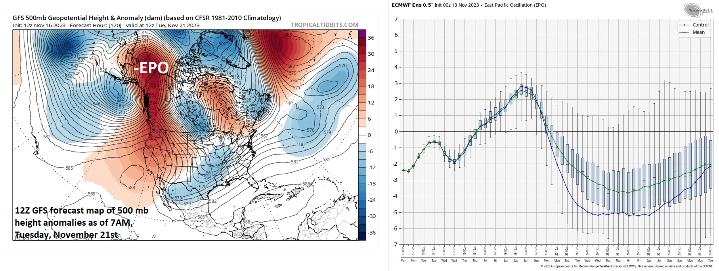
An upper-air pattern change that will feature strong high pressure ridging along the west coast of Canada (i.e., -EPO) will set the stage for the transport of this unusually cold air mass to drop south and east from northwest Canada into the US. The teleconnection index known as the Eastern Pacific Oscillation or EPO will drop sharply into “negative” territory next week (right plot) and this usually signals the formation of a strong ridge of high pressure in the upper part of the atmosphere from near Alaska to western Canada and that is exactly what is depicted in the 12Z GFS forecast map (left) by next Tuesday. Maps courtesy NOAA, tropicaltisbits.com (left); Weather Bell Analytics, NOAA (right)
In much of the southern and eastern Mid-Atlantic and the coastal sections of the Northeast US, rain is likely from Tuesday into Wednesday and some of the rain can be heavy at times which has been a rarity in recent weeks. However, in the interior, higher elevation sections of the northern Mid-Atlantic and Northeast US, there may be enough cold air for some accumulating snow to fall from later Tuesday into Wednesday.
In the cold sector of the Great Lakes (primary) low pressure system, winds may howl out of the W-NW by the middle of next week and lake-effect snow bands could become very numerous just downstream of the still relatively warm waters of the lakes - potentially resulting in copious amounts of snowfall in some locations. By the time we get to Thanksgiving Day, the strong storm system(s) are likely to have moved into southern Canada and the widespread and impressive cold air outbreak will likely have reached all the way to the eastern seaboard - all making for a cold Turkey Day across much of the nation.
Meteorologist Paul Dorian
Arcfield
arcfieldweather.com
Follow us on Facebook, Twitter, YouTube
Video discussion: