
12:30 PM | **An Arctic blast…significant lake-effect snows…snow showers on Tuesday into I-95 corridor with quick small accumulations possible…teleconnection indices as November winds down**
Paul Dorian

Arctic air will become firmly established in the Mid-Atlantic region on Tuesday and Tuesday night and many places will experience the lowest temperatures of the season so far. In addition, winds will remain persistently strong (W-NW direction) into mid-week making it feel even colder than the actual air temperatures. Map courtesy NOAA, tropicaltidbits.com
Overview
Arctic air is charging across the Great Lakes today and right toward the Mid-Atlantic region. Winds will increase markedly later today in the DC-to-Philly-to-NYC corridor following the passage of a strong cold frontal system. As the Arctic air pushes across the still relatively warm waters of the eastern Great Lakes, lake-effect snows have developed and there will be several inches of accumulation in some of the places just downstream by the middle of the week. There can even be some snow shower and snow squall activity on Tuesday all the way into the I-95 corridor as the Arctic air mass becomes firmly established. In fact, quick small accumulations are on the table in the I-95 corridor which can make for hazardous travel conditions. Temperatures will reach the lowest levels of the season so far late tomorrow night in the DC-to-Philly-to-NYC corridor and persistent winds will make it feel even colder than the actual air temperatures. A look at some teleconnection indices such as the NAO, AO and MJO suggest this Arctic outbreak will be rather short-lived and indeed, temperatures should moderate noticeably for the late week and weekend.

Significant lake-effect snows are likely between today and mid-week in areas just downstream of the still relatively warm Great Lakes and snow shower/snow squall activity on Tuesday can make it all the way into the I-95 corridor with quick small accumulations on the table. Map courtesy NOAA, tropicaltidbits.com
Arctic blast…lake effect snows
Snow bands have already formed today just downstream of Lakes Erie and Ontario as Arctic air charges across the still relatively warm waters of the eastern Great Lakes. Significant lake-effect snow accumulations are likely during the next couple of days in some of the usual places just downstream of Lake Erie (e.g., Cleveland, Erie, Buffalo) and Lake Ontario (e.g., Syracuse, Watertown). In fact, snow shower/snow squall activity is likely to make it all the way into the DC-to-Philly-to-NYC corridor by early Tuesday morning and quick small accumulations are possible that can quickly deteriorate road conditions. The Arctic air will ride into the DC-to-Philly-to-NYC corridor later today and tonight on increasingly strong W-NW winds. The core of the Arctic outbreak will be in place across the Mid-Atlantic region on Tuesday and Tuesday night and many places will experience their lowest temperatures so far this season late tomorrow night into early Wednesday morning. In addition, the winds will remain persistently strong right into the mid-week resulting in even lower wind chill values compared to the actual air temperatures.

Two teleconnection indices known as the North Atlantic Oscillation (NAO, top plot) and Arctic Oscillation (AO, bottom plot) drop well into negative territory during the next few days; however, they quickly rebound after that towards the neutral or slightly positive zones suggesting this Arctic outbreak will be rather short-lived in the eastern US. Plots courtesy NOAA
Teleconnection indices
One of the ways to monitor the prospects (and potential longevity) of cold air outbreaks into the eastern states during the winter season is to monitor trends of so-called “teleconnection” indices including the North Atlantic Oscillation (NAO), Arctic Oscillation (AO) and Madden-Julian Oscillation (MJO). The general concept in the monitoring of teleconnection indices is that historical observations have shown that pressure, temperature, and precipitation patterns in one part of the world can indeed provide clues as to what one can expect in other areas. The NAO and AO index values provide information on temperature and pressure patterns across the North Atlantic Ocean and Arctic regions and when they drop into negative territory for sustained periods during the winter season, there is often a strong correlation with cold air outbreaks that make their way into the eastern US from higher latitudes. In this current scenario, these two closely-related indices do indeed drop well into negative territory over the next couple of days. However, they both bounce back rather quickly towards the neutral or slightly positive zones later this week suggesting this Arctic outbreak will likely be rather short-lived in the eastern US.

The MJO will rotate in coming days into what is typically a relatively warm phase (#3) during this early winter season supporting the idea that this Arctic air outbreak will be rather short-lived in the eastern US. Plot courtesy NOAA
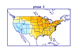
During the November/December/January time period, “phase 3” of the Madden-Julian Oscillation (MJO) often results a warmer-than-normal temperature pattern across the eastern two-thirds of the nation. Map courtesy NOAA
Another index known to meteorologists as the Madden-Julian Oscillation or MJO is tracked to determine the positioning of a tropical disturbance that regularly pushes through the tropical regions around the world. The location or “phase” of the MJO can provide clues on temperature and precipitation patterns in non-tropical areas with a known dependence on the particular time of year. In this particular scenario, the MJO is about to push into what has typically been a relatively warm phase (#3) for the eastern US in the early winter season - adding support to the idea that this Arctic outbreak will be rather short-lived. Looking ahead, the MJO is likely to rotate into colder phases later in the month of December likely resulting in a return to a colder temperature pattern and potentially, an increased chance for accumulating snow.
Meteorologist Paul Dorian
Arcfield
arcfieldweather.com
Follow us on Facebook, Twitter, YouTube
Video discussion: