
12:15 PM | **Heavy rain event with strong and potentially damaging winds on the table for Mid-Atlantic/NE US late Sunday…back-end changeover to snow/ice across interior sections an increasing threat**
Paul Dorian

A strong low-level jet streak will play a role in the late weekend storm system that will affect the Mid-Atlantic/NE US. Winds will become quite strong with potentially damaging gusts on the table; especially, along coastal sections. Map courtesy NOAA, tropicaltidbits.com
Overview
Signs continue to point to a heavy rain event for the Mid-Atlantic/Northeast US in the late Sunday/Sunday night time period with strong and potentially damaging winds. In addition, with an eventual shifting of the main surface low pressure system to the east coast, there is a threat for back-end snow and/or ice across interior, higher elevation locations. In fact, this changeover threat across interior sections may actually be increasing as we get closer to event time with the expected storm track now somewhat slightly farther to the south and east. This trend allows for a quicker intrusion of colder air on the tail end of the storm. As it stands now, several inches of snow are possible across upstate New York and interior sections of New England and perhaps some frozen precipitation can make it not too far to the northwest of the I-95 corridor. Elsewhere, this weekend storm system may threaten the Deep South with severe weather including possible tornadic activity in the region from Arkansas/Louisiana to Alabama.

A strong upper-level jet streak will play a role in the late weekend storm system that will affect the Mid-Atlantic/NE US. Jet streaks at multiple levels of the atmosphere will aid in the intensification of low pressure that forms along a frontal boundary zone. Map courtesy NOAA, tropicaltidbits.com
Details
Strong jet streaks at multiple levels of the atmosphere will provide the catalyst for the formation of a powerful surface low pressure this weekend that can end up having a big impact across a large part of the East and South. An upper-level low will push eastward from the Pacific Ocean into the Pacific Northwest on Thursday and then drop southeastward sliding into the south-central states by the early part of the weekend. Aided by an intensifying upper-level and lower-level jet streaks, this upper-level low will deepen substantially by later in the weekend and, by the time Sunday afternoon rolls around, there is likely to be a strong upper-level low sitting over the Tennessee Valley with a “negatively-tilted” trough axis.
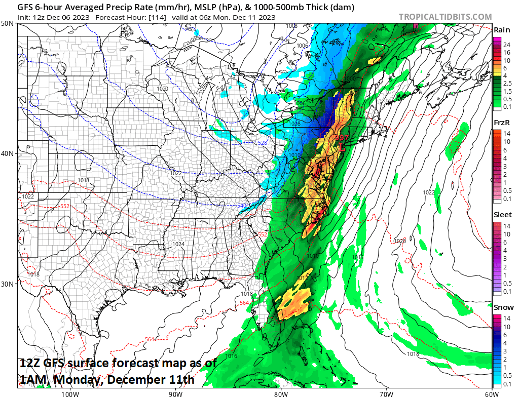
Heavy rain is on the table for the Mid-Atlantic/NE US on Sunday night and a changeover to snow/ice on the back end can result is several inches of the white stuff across upstate NY and interior New England. Map courtesy NOAA, tropicaltidbits.com
At the surface, a strong cold front will slide slowly to the east this weekend and low pressure will intensify along the frontal boundary zone. This surface low will initially take an inland track to the north and east, but it could end up right near or over the east coast by later Sunday night and early Monday. With this kind of track and given its strong upper-level support, there can be numerous kinds of weather effects across the eastern third of the nation. In the warm sector, severe weather could very well break out in the Deep South this weekend and tornadoes may become a threat across places like Arkansas, Louisiana, Mississippi and Alabama and rainfall there can become heavy with the strong-to-severe thunderstorm activity.

An upper-level low will take on a “negative-tilt” by late in the weekend and strong surface low pressure will form along a frontal boundary zone. Map courtesy NOAA, tropicaltidbits.com
In the Mid-Atlantic and Northeast US, all signs point to heavy rain from late Sunday into Sunday night with thunderstorms possible as part of the mix. In addition, winds can become quite strong with the potential of damaging wind gusts; especially, along coastal sections given the expectation of a very strong low-level jet. These winds will initially cause a surge of mild air to ride up from south-to-north along the east coast and out ahead of an incoming strong cold frontal system.
Once the cold front slides through the Mid-Atlantic/Northeast US sometime on Sunday night, colder air will quickly wrap into the storm system from the northwest and back-end snow is quite likely across interior, higher elevation locations with several inches of snow possible in upstate New York and interior New England. There is even the chance for a transition to accumulating snow later Sunday night all the way into or just to the north and west of the I-95 corridor region from DC-to-Philly-to-NYC. This colder air mass will encompass much of the eastern third of the nation through the first half of next week.
Meteorologist Paul Dorian
Arcfield
arcfieldweather.com