12:30 PM | **Heavy rain/strong storms near Philly, S NJ shortly...Arctic blast this weekend and a snow threat primarily north of PA/MD border**
Paul Dorian

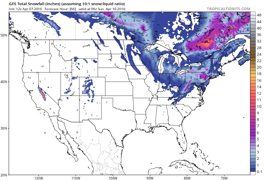
12Z GFS total snowfall map for weekend system; map courtesy tropicaltidbits.com, NOAA
Overview
Another Arctic air mass will move into the Mid-Atlantic region this weekend and this one will be accompanied by an accumulating snow threat primarily for areas to the north of the PA/MD border. A strong upper-level wave of energy will spin off a “clipper” type of low pressure system that is likely to trek from west-to-east across Pennsylvania on Saturday. The highest precipitation amounts are likely to fall “along and to the north” of this expected storm track which will give the greatest chance for accumulating snow in the New York City metro region and the least likely chance to the south across DC - Philly falls somewhere in the middle. Behind the “clipper", very cold air will pour in on increasingly strong winds during late Saturday and another widespread deep freeze is likely throughout the region by early Sunday morning.

12Z GFS 500 mb forecast map for Saturday morning showing vigorous upper-level wave of energy over PA/MD border; map couresy NOAA
Short term- heavy rain/strong storms in SE PA, S NJ early this afternoon
In the immediate time frame, heavy rain and strong thunderstorms will head into SE PA/Southern NJ and localized flooding may occur along with wind gusts to 45 mph. This intense rainfall region should move into the NYC metro region by mid-afternoon. After the heavy band passes by, showers will be much more of a scattered variety for the remainder of the afternoon and evening, and then it’ll turn noticeably colder late tonight.

12Z GFS total precipitation forecast for upcoming system with highest amounts near NYC and least near DC; map couresy NOAA
Snow threat late tomorrow night/Saturday
As the “clipper” system heads east from the Ohio Valley late tomorrow night, snow could break out across the Mid-Atlantic region in the wee hours of the morning – likely mixed with rain at times. On Saturday, the system will strengthen as it reaches the Mid-Atlantic coastline and precipitation amounts will tend to increase along and to the north of the storm track. This is likely to result in little in the way of total precipitation across the DC metro region and the highest amounts in and around the NYC metro region with Philly somewhere in the middle. As far as accumulating snow is concerned, it is not out of the question that a coating of snow takes place on grassy surfaces in the far northern and western suburbs of the District; especially, in higher elevation locations. A coating to an inch or two is possible on grassy surfaces across SE PA on Saturday with the best chance for this to the north and west of the metro region; especially, in higher elevation locations. The greatest threat for accumulating snow from this system in the Mid-Atlantic I-95 corridor will likely take place from interior NW NJ to the NYC metro region where a few inches can accumulate; primarily on grassy surfaces and in the higher elevation locations to the north and west of the NYC metro region. Stay tuned.
Meteorologist Paul Dorian
Vencore, Inc.