
10:30 AM (Tuesday) | ****A major winter storm to produce accumulating snow, ice and rain in the Mid-Atlantic region****
Paul Dorian

12Z NAM forecast maps from 7AM Wednesday (forecast hour 24) to 7AM Thursday (forecast hour 48); courtesy NOAA/EMC, tropicaltidbits.com
Overview
A major winter storm will impact the Mid-Atlantic region on Wednesday and Wednesday night with significant accumulating snow on the front end in many areas before a changeover to ice and rain. An initial low pressure system will head towards the western Great Lakes on Wednesday and a secondary low pressure will form near the Mid-Atlantic coastline. Another key player will be strong cold high pressure that will be situated to our north at the beginning of this mid-week event and it will anchor cold, dense low-level air that will be reluctant to give up its ground. Snow should break out in the early morning hours on Wednesday in the DC metro region, around mid morning in Philly, and then during the mid-day or early afternoon hours in NYC.

12Z NAM forecast map of strong jet streak over New England early Wednesday morning which will result in strong upward motion in the Mid-Atlantic region aiding in the outbreak of snow; courtesy NOAA/EMC, tropicaltidbits.com
Major storm
A mid-week mess is on the way for the Mid-Atlantic region that will likely include significant accumulating snow on the front end in some areas before a changeover to ice and rain. Strong high pressure will build to our north later today and act as a key player in this unfolding winter weather event for the Mid-Atlantic region. By late tonight, there will be lots of moisture pushing northeastward from the Gulf of Mexico into the Mississippi and Tennessee Valleys. The area of high pressure will lock in a cold, dense air mass in the lower levels of the atmosphere – at least for the onset of a mid-week storm system – setting us up for “overrunning” precipitation as warmer air initially rides up and over the surface air mass. One surface low will trek from the Gulf coast states to the Great Lakes while a secondary low develops near the Mid-Atlantic coastline – quite similar to the setup recently which resulted in snow, ice and rain for the Mid-Atlantic. Another feature that will enhance upward motion in the Mid-Atlantic region will be a powerful jet streak over New England early Wednesday morning. The Mid-Atlantic region will be in the “right, entrance” region of this jet streak which favors strong upward motion and this will help in the development of snow.
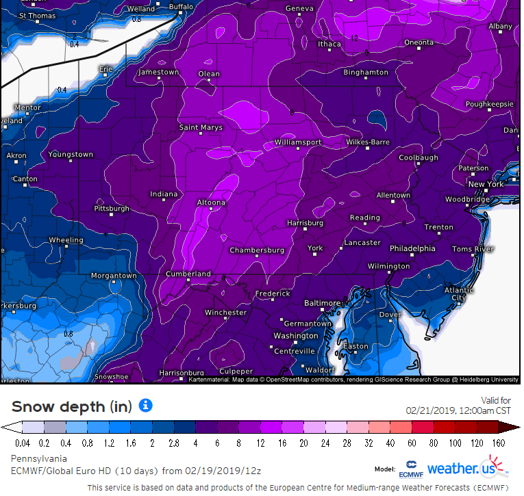
12Z (Tuesday) Euro forecast map of snow depth by midnight Thursday with 4+ inches in the DC-to-Philly-to-NYC corridor; courtesy ECMWF, weather.us
Snow is likely to break out in the DC metro region early tomorrow morning and then expand northeastward towards the Philly and NYC metro regions. By later Wednesday, milder air will advance into the region as winds turn more to the southeast and this should result in a changeover from snow to sleet and freezing rain and then ultimately to plain rain by later tomorrow night. The low pressure area moves away on Thursday and allows for high pressure to build in from the west. Temperatures may actually climb to 50+ degrees on Thursday afternoon in much of the I-95 corridor.

“Frontogenesis” in the upper part of the atmosphere can contribute to some heavy bands of precipitation on Wednesday; courtesy NOAA/EMC, tropicaltidbits.com
Snowfall estimates (and arrival times) are listed below for the DC, Philly and NYC metro regions. Note - the higher amounts in the snow accumulation ranges should occur on the western side of the given metro region, lower amounts in the city and points south and east of there. The snow and sleet can come down heavily at times on Wednesday before the changeover to freezing rain/rain. Roads will quickly deteriorate shortly after snow begins and untreated surfaces will remain slick throughout the day.
Accumulation estimates (3-hour window arrival times):
DC: 4-7 inches (4-7AM)
Philly: 3-6 inches (7-10AM)
NYC: 2-5 inches (10AM-1PM)
Meteorologist Paul Dorian
Perspecta, Inc.
perspectaweather.com
Video discussion: