
9:50 AM | **Powerhouse storm in nation’s midsection to have wide ranging impacts**
Paul Dorian

Numerous watches and warnings have been posted by NOAA across the nation as this powerhouse storm system will have wide-ranging impacts; map courtesy NOAA
Overview
All the ingredients are coming together for rapid intensification today of low pressure as it pulls out of Colorado and moves into western Kansas. In fact, the central barometric pressure of this intensifying low pressure system could bottom out near 28.67 inches later today and some spots may very well reach record low levels; especially, across Colorado and Kansas. The combination of a strong “negatively-tilted” wave of energy in the upper atmosphere, sharp low-level temperature gradient, and powerful jet streaks in the atmosphere will help generate this powerhouse storm system that will have wide ranging impacts from blizzard conditions to its north and west to extreme winds and potential severe thunderstorms on its south and east side.
Wind gusts are likely to surpass hurricane-force levels later today in a wide part of the nation from New Mexico/Texas to southern Nebraska and perhaps even to 90+ mph in places like Colorado and Kansas. These extreme wind gusts are unfortunately likely to result in widespread power outages, downed or damaged trees and very difficult travel conditions. Blizzard warnings have been posted all the way from Colorado to Minnesota/North Dakota for the expected heavy snowfall and extremely strong winds.

Central pressures could bottom out in record low territory later today in many spots across the central US and extreme winds will take place to the south and east of the surface low; courtesy NOAA/EMC, tropicatidbits.com
Details
Vigorous energy in the upper part of the atmosphere will slide into Kansas over the next few hours and will help to set off rapid intensification of low pressure. The perfect combination of a “negatively-tilted” deep trough in the upper atmosphere, intense low-level temperature gradients, and multiple nearby jet streaks will combine to generate this powerful storm system. Some recent computer model forecasts even predict an “eye” may form later today similar to what is often seen with hurricanes.

Vigorous energy in the upper atmosphere plays a key role today in the rapid intensification of the storm system; courtesy NOAA/EMC, tropicaltidbits.com
In the cold sector, heavy snow is likely to be deposited over the next 12-24 hours from the Colorado Rockies to the Dakotas and northwestern sections of Minnesota. Given the expected intensity of the pressure gradient later today and the powerful jet streaks aloft, surface-level winds can easily gust past 80 mph in many spots from the Southwest US to the central Plains. Places like Denver, Colorado can see white-out conditions today with hurricane-force winds and blinding, heavy snowfall. Severe weather is also on the table later today and early tonight given the dynamics of this unfolding mid-week powerhouse storm; especially, in the southern Plains and Lower Mississippi Valley.
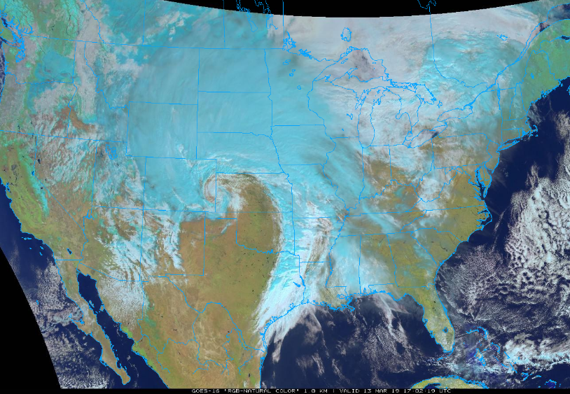
GOES-16 “natural” color image of developing storm system over the nation’s midsection; courtesy NOAA/GOES, College of DuPage
The storm will work through its most intense phase during the next 12 hours or so and then begin a slow weakening process later tonight as the current “concentric” upper-level low becomes “stretched out” as it heads northeastward towards the Great Lakes. Nonetheless, significant snow will continue later tonight and Thursday across the Northern Plains and winds will remain very strong; especially, to the south and east of the low pressure system. The residual low pressure system will drag a cold front into the eastern states by Friday and milder air will flow northward into the Mid-Atlantic region ahead of it. In fact, temperatures should reach the 50’s in the I-95 corridor on Thursday and then the 60’s on Friday, but there will be occasional rain and possible thunderstorms as the cold front approaches. Colder, drier air will follow the late week frontal passage for the upcoming weekend and there should be some sunshine each weekend day in the Mid-Atlantic region.
Meteorologist Paul Dorian
Perspecta, Inc.
perspectaweather.com
Video discussion: